Study: Walking in Massachusetts – The 496 Most Dangerous Intersections for Pedestrians
In 2015, nearly 15 people a day were killed while walking or running along U.S. roads. Driver inattention or distraction, increased speeds, and unsafe road design have all contributed to make walking a dangerous proposition in the United States.
This is true in Massachusetts as well and is not exactly a new phenomenon.
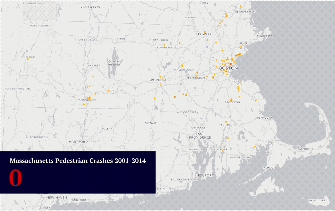
From 2001-2014, over 25,000 pedestrians were struck by vehicles in Massachusetts (more than 5 every day) – leaving hundreds dead and thousands injured. As advocates for injury victims, the Boston personal injury attorneys at Sweeney Merrigan wanted to find out where and why these collisions occur. So, we enlisted data visualization firm 1Point21 Interactive to help.
Our analysis found that nearly 14 percent of all pedestrian collisions and 13.4 percent of the resulting injuries occurred at just 496 intersections – far less than one percent of all intersections throughout the state. Each one of the 496 had at least 5 pedestrian collisions within the study time frame.
Walking in Massachusetts: The 496 Most Dangerous Intersections for Pedestrians
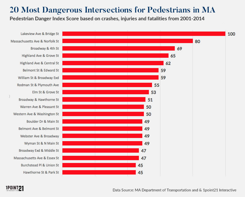
*PDI is our Pedestrian Danger Index, a formula that assigns different weights to total crashes, injuries and fatalities.
[wpdatatable id=8]
20 Intersections with the Highest PDI
Topping the list is the intersection at Lakeview Ave & Bridge Street in Lowell. Taking a look at an aerial view on Google maps, it’s easy to see how pedestrian collisions are a frequent event here.
When creating a scatterplot of all 496 intersections in our study, as expected, we found a correlation between the number of crashes (collisions) and the number of injuries. At most intersections, the number of collisions exceeds the number of injuries. However, we can see some clear outliers, such as Wyman & N. Main Street, where the number of injuries is greater than the number of crashes. Even though Wyman & N. Main Street had only 7 total collisions, there were 14 injuries here, making it more dangerous than most other intersections in our study.
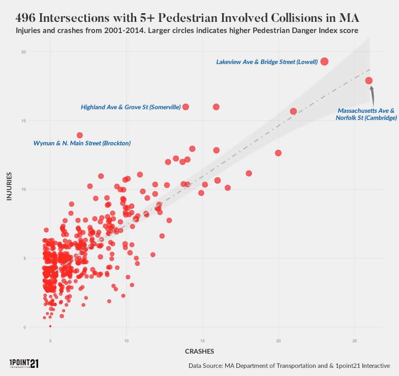
Table of Contents
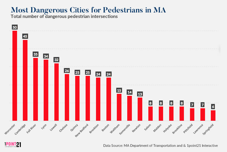
Concentrations of Dangerous Intersections by City
The highest concentrations of dangerous intersections were found in Worcester (50), Cambridge (45), Fall River (35), Lynn (34) and Lowell (32) respectively. Surprisingly, Boston – the largest city in the state – ranked 9th with only 24. One might expect the largest city to have a much higher number. More on this below.
Other Insights
- From 2001- 2014, 25,056 pedestrians were struck by vehicles – resulting in 871 fatalities and 19,361 injuries.
- 6,696 people were hit while inside marked crosswalks at intersections.
- 785 people were walking, running or standing on a sidewalk when they were struck. Of those, 627 were injured and 26 were killed.
- Drivers in the 25-34 age range were involved in the highest number of pedestrian related injury incidents, followed by the 45-54 age group.
- Both non-fatal injuries and fatalities were highest once speed limits reached 30 mph. *More on that below
- According to the study, there was no “improper driving” cited in 10,141 pedestrian collision incidents. Driver inattention was cited as the driver action in 3,043 pedestrian collisions followed by reckless/carelessness in 1,205 crash incidents.
- Vehicle left turns were much deadlier for pedestrians than right turns. Drivers making left turns struck 3,444 pedestrians, killing 43, compared to 1,474 and 10 for right turns.
Walking in Boston
Despite being named the third most walkable city in the U.S. by walkscore, streets in Boston and its surrounding cities still pose a significant driver safety hazard to pedestrians.
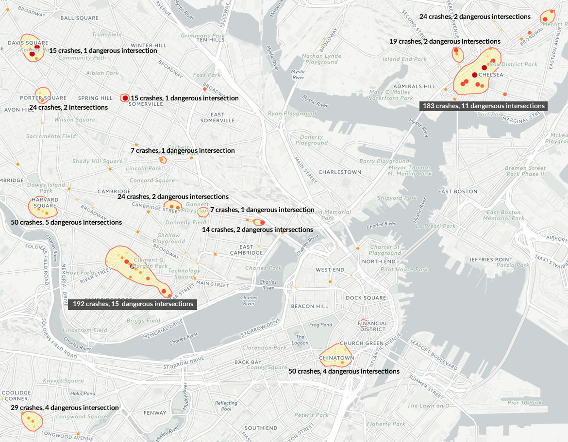
Nearly 11,000 pedestrian collisions occurred in the Greater Boston area in this time frame – leading to 307 deaths and 8,108 injuries. Additionally, using geospatial analysis, we identified 12 clusters in the area (in Boston, Cambridge and Chelsea) with a high concentration of both pedestrian collisions and dangerous intersections.
The most notable of these clusters is found along Massachusetts Avenue in Cambridge. Nestled between M.I.T. and Harvard University, this stretch of Massachusetts Ave. was the site of 196 pedestrian collisions during our study period. This area also contains 15 of the dangerous intersections identified by our analysis, the most of any area in the entire state.
Closely following Massachusetts Ave. is the high crash cluster along Broadway in Chelsea, with 183 pedestrian collisions and 11 dangerous intersections. Other high incident areas include Harvard Square, Chinatown, Porter Square and Davis Square.
Greater Boston: Concentrations of Pedestrian Collisions and Dangerous Intersections
It is important to note the relatively low numbers of dangerous intersections we found in Boston as well as the near absence of high collision clusters within the city (when compared to surrounding cities). Several reports have found that the city of Boston has failed to record and report all pedestrian collisions to the Massachusetts Department of Transportation for years. Therefore, these data, perhaps, provide a less than complete picture of the issue within the city. Our findings seem to highlight that fact. Consider that Boston, with a population more than three times the size of Worcester, had less than half the number of dangerous intersections and very few high risk clusters.
Perhaps this study and others like it will help compel the city to take more action and more accurately report pedestrian collisions.
How to Increase Pedestrian Safety
Given these data, it’s no surprise that cities throughout Massachusetts are lowering speed limits in their high traffic core areas. Spurred by a recent report from the Boston mayor’s office which showed an increase in fatal pedestrian crashes, the city’s default speed limit was decreased from 30 to 25 miles per hour. The report also initiated several other roadway changes this year targeted at improving safety for pedestrians and tackling the problem of distracted and impaired driving. Other cities in Massachusetts are following suit as well – Cambridge has also reduced its default speed limit to 25 miles per hour.
This is important because, especially for pedestrians, speed kills. Research shows that, regardless of a driver’s age, once vehicle speeds reach 30 mph, injuries and fatalities in a collision are much more likely. For example, a pedestrian has roughly a 90% chance of surviving a collision at 20 mph – but if you double that speed, the chances of survival plummet to a 10% chance.
Speed also makes it much more difficult to avoid a collision with a pedestrian. At just 30 mph a car is traveling approximately 44 feet (about 3 car lengths) per second – which means the braking distance is about double that (89 feet). While an alert driver may brake in time to avoid a pedestrian, an inattentive or distracted driver has very little chance of reacting in time.
Pedestrians should take every precaution to be watchful and alert to their surroundings.
- Don’t talk on the phone and avoid use of headphones and other sources of distraction when you are in traffic areas.
- Always remember it is easier for you to see oncoming cars than for drivers of cars to see you.
- Always cross streets at crosswalks and other places designed for pedestrians.
- Walk on the sidewalk whenever there is one; if not, walk facing oncoming traffic.
- If walking at night, carry a flashlight or wear reflective clothing so that drivers can see you.
Drivers can help save lives by
- Avoiding the use of cellphones and other sources of distraction while driving
- Observing posted speed limits and traffic laws
- Remaining watchful when in areas populated by pedestrians and bicyclists
Methodology
Our study is based on data obtained from the Massachusetts Department of Transportation. We analyzed over 25,000 crash records and used geospatial analysis to find which intersections or zones had the highest pedestrian collision frequency. The Pedestrian Danger Index is based on the number of collisions, injuries and fatalities associated with each intersection. A more detailed methodology is available upon request.